Strategic agreements integrate Topcon technology into solutions from Bentley Systems and Worldsensing
Topcon Positioning Systems has announced strategic agreements with Bentley Systems and Worldsensing to integrate its advanced GNSS (Global Navigation Satellite System) technology into the companies’ innovative software and connectivity solutions.
“This series of agreements is an example of the innovation and collaboration that is driving technology adoption in our industries,” said Ian Stilgoe, vice president of Emerging Business for Topcon. “Not only are we improving workflows and operational gains for end users, but we are also expanding Topcon GNSS technology into exciting new markets and use cases.”
Bentley Systems
As part of its agreement with Bentley Systems — an industry-leading infrastructure engineering software company whose solutions are used by professionals, and organizations of every size, for the design, construction, and operations of roads and bridges, rail and transit, water and wastewater, public works and utilities, buildings, mining and industrial facilities — Topcon will provide access to its powerful web-based GNSS processing engine. Bentley has integrated this technology into their advanced iTwin IoT monitoring solution.
“Combining our expertise in GNSS technology with Bentley’s world-class software platforms will allow users to leverage accurate and real-time geospatial information for improved decision-making and operational effectiveness,” Stilgoe said.
“We’re excited to announce this integration of Topcon’s GNSS technology into our suite of IoT-based monitoring solutions,” said Steve Bentley, Senior Director of Infrastructure IoT for Bentley Systems. “This integration will enable our users to combine cost-effective geospatial monitoring data with the wide range of geotechnical, environmental, and structural sensor data that we already support — providing real-time asset intelligence that can be combined with engineering data to advance infrastructure digital twins.“
Worldsensing
A global IoT pioneer in connectivity tools for geotechnical, structural and environmental monitoring, Worldsensing has integrated the Topcon AGM-1 GNSS receiver with its Thread X3 broadband sensor, used to monitor geohazards such as rock falls and landslides in pit mines, rail embankments and other ground structures.
“This will empower industry professionals to proactively identify potential risks for subsidence, heave, landslip, settlement and undertake preventive measures,” Stilgoe said. “Mining operations and the rail industry will greatly benefit from this collaboration. Professionals in these fields can now access a comprehensive monitoring solution that ensures the safety of their operations while optimizing productivity, all at a much lower cost than before.”
This integration marks a significant milestone in geohazard monitoring technology, offering a plug-and-play sensor solution that enables real-time detection and analysis of potential risks. By leveraging GNSS technology as the core component, Topcon and Worldsensing bring cost-effectiveness and efficiency to ground-movements monitoring applications while reducing the initial investment required for GNSS monitoring.
“This new offering aims to address the common challenges facing IoT deployments today, namely access to end-to-end, scalable, and flexible solutions”, said David Deprez, Managing Director of Worldsensing. “We are facilitating IoT mass deployment for GNSS monitoring in collaboration with leading technology providers in the field. Customers will quickly recognize the value of this game-changing offer.”
A trilateral collaboration to boost static GNSS cost-efficiency
That is why Worldsensing, Topcon and Bentley Infrastructure IoT join forces to offer the most cost-effective accurate positioning system for ground movements monitoring in the market.
A Topcon AGM-1 GNSS receiver connected to a Worldsensing ThreadX3 will collect positioning data with 2-3mm precision to assess vertical and horizontal movements on the ground in real-time. The connection of the positioning system to Sensemetrics, Bentley Infrastructure IoT’s software, will allow engineering companies to configure and manage GNSS data and act upon the evolution of ground movements on-site.
The trilateral collaboration offers the possibility to deploy the most cost-effective, end-to-end accurate positioning system for ground stability monitoring, including:
A competitive technological solution reducing the initial investment required for GNSS monitoring
An easy setup solution, taking on average half as much time to install as other available solutions, ensuring competitiveness and increasing project throughput
Flexibility in configuration and ultimately precision, thanks to dynamic processing intervals
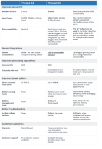
Thread X3, a key component of Worldsensing’s core communications portfolio
Thread X3 is a key component of Worldsensing’s core communications portfolio, geared towards customers requiring broadband sensor connectivity for high-data rate, high-power, or high-speed industrial projects.
If you currently use its predecessor, Thread X2, and are contemplating an upgrade to the latest version, this article outlines the key features of Thread X3 compared to Thread X2 to assist you in making the next step.
Expanding sensor integrations with our Digital Data Logger
Aligned with Worldsensing’s mission to enhance the reliability, security, and scalability of global monitoring systems using advanced IoT connectivity tools, we are committed to expand the sensor integrations with the Worldsensing Digital Data Logger. Using our Digital Data logger along with existing Worlsensing LoRa networks, engineers can deploy digital sensors in areas with no connectivity and stream data wirelessly from up to 15 km range, using data loggers that require minimum maintenance.
We are pleased to welcome two new sensor manufacturers into the portfolio that open the door to new Environmental Monitoring Applications: Gill Instruments and Meter Group. In addition, we are enhancing the current sensor integration with Geokon’s tiltmeter so you can take full advantage of the sensor’s capabilities.
Geokon: New Compatibility Modes
We are introducing new compatibility modes with Geokon digital tilt sensors to ensure full interoperability between systems. This update includes:
Expanded Measurement Ranges: Our Digital data logger has been enhanced to accommodate broader tilt measurement ranges, bringing it in line with the specifications of Geokon tilt sensors. Engineers can now leverage the full sensor capabilities and get high quality information through.
Three-Axis Inclination Measurement: Clients can now take advantage of the full triaxial capabilities of Geokon inclination and tilt sensors such as models 6185, 6190, and 6195 when connected to the Digital data logger.
Teros 32 Soil Tensiometer by Meter
We enhanced the capabilities of our Digital data logger with the integration of a new soil monitoring sensor. The Teros 32 Soil tensiometer by Meter provides an accurate method for directly measuring water potential in the wet range.
The digital logger connects to the TEROS 32 RS 485 4-wire version, MODBUS RTU and SDI-12 protocols, making it now feasible to connect chains of up to 40 tensiometers to a single digital data logger. The integration enables the transmission of both soil water potential and soil temperature measurements, along with the transmission of installation angles.
Maximet Weather Stations by Gill
We are happy to announce the addition of Gill Instruments to our digital integrations portfolio. Clients can now record and transmit data from any Maximet weather station using Worldsensing’s Digital Data Logger according to a specified reporting period.
Why Choose Worldsensing Digital Logger?
Robustness: Industry-grade IP68 devices fully capable of capturing data from -40º to 80ºC. Battery-powered with 3.6V C-Size user-replaceable high energy cells. Up to 25 years of battery lifetime
Simple connect and collect: Mobile app to easily configure devices through internal USB port. Selectable reporting periods from 30s to 24h to adapt to your monitoring needs. Field samples and signal coverage test when connected to the app.
Versatility: Suitable for unattended, large scale projects and excellent performance in both underground and surface monitoring systems. Integration with leading geotechnical and structural instrumentation and monitoring sensors and systems and the possibility to leverage existing Worldsensing networks to scale up with new monitoring systems.
Worldsensing expands environmental monitoring solutions with Vaisala weather transmitters
In a significant stride toward advancing environmental monitoring capabilities, Worldsensing has announced the expansion of compatibility with Vaisala’s WXT530 series of weather transmitters. This development marks the culmination of their partnership, initiated with the introduction of compatibility for the WXT536 model in August 2020.
With this cooperation, Vaisala, a global leader in weather, environmental, and industrial measurements, and Worldsensing, the global leader in connectivity for remote monitoring, aim to contribute to a safer and more resilient world, addressing challenges caused by climate change through the use of advanced remote technology.
Meteorological monitoring solutions to mitigate climate change challenges
Air pressure, temperature, humidity, rainfall, wind speed, and wind direction—these weather conditions are highly influenced by global warming. Over the past decade, the rise in extreme meteorological events has significantly impacted landscapes, structural integrity, and various activities.
Actively monitoring structures with the aim of anticipating the effects of climate change-induced conditions and mitigating their impact to the fullest extent possible has become imperative for civil engineering companies involved in construction, mining, or off-highway industries.
Remote solutions are increasingly preferred for their cost-effectiveness, accuracy, and reliability in measuring weather conditions, capturing a range of elements such as wind, rain, temperature, and barometric readings.
Complementing geotechnical and structural monitoring with weather transmitters
The Vaisala WXT530 series of weather transmitters seamlessly complements the information collected by Worldsensing in geotechnical and structural monitoring projects. Meteorological events often serve as precursors to landslide activation and can impact the stability of structures.
Worldsensing’s digital Data Logger and ThreadX3 are now compatible with the entire WXT530 series. This expanded compatibility facilitates more efficient solutions tailored to clients’ needs, allowing them to capture any combination of wind, rain, temperature, and barometric readings by selecting the most suitable WXT530 model.
Key configuration details of the WXT530 series:
RS-485, Modbus RTU, for compatibility with the Loadsensing LS-G6-DIG-2 data logger. In this case, external power is required for continuous meteorological parameter measurements.
RS-232, Standard ASCII, for compatibility with ThreadX3. Here, Thread can provide continuous power to the weather transmitter.
Moreover, the WXT530 series proves to be a great addition to environmental controls conducted with Thread X3. This includes flood detection achieved by integrating meteorological measurements with water level readings in streams and channels.
For more information on weather transmitters and their applications, get in touch with us.
Worldsensing forges new partnership with TecWise/Comms International Group
The global leader in connectivity for remote monitoring, Worldsensing, has forged a new multi-continental partnership with TecWise and the larger Comms International Group of Companies, marking a significant milestone in their drive to uplift industry standards and provide value to clients. This collaboration heralds an era of increased connectivity in the rapidly evolving mining/metals, rail/port and infrastructure monitoring sectors.
With strategically positioned teams & offices in Latam, Africa, Europe as well as select Central Asian nations; Comms International is uniquely positioned to support their clients/partners across continents. The company’s deep-rooted understanding of the complexities of mining operations, strengthened by their technical expertise, has led to their recognition as a trusted partner.
The partnership with Worldsensing reinforces TecWise/Comms International’s unwavering commitment to driving heavy industry and civil infrastructure industry standards forward to improve efficiency, safety, and productivity.
A multi-continental collaboration for real-time geotechnical & environmental monitoring
The partnership between Worldsensing and TecWise/Comms International signals a set of multi-continental synergies that are set to greatly impact the sectors that they jointly serve. With Worldsensing’s prowess in developing IoT technology aimed at monitoring large-scale infrastructure and TecWise/Comms International’s proven competence in creating custom integrated technology solutions, the fusion of such expertise signifies an influential collaboration.
TecWise Latam is now the Brazilian value-added distributor focused on supporting a network of Worldsensing ESPs across the country, while integrating Worldsensing products across its own projects. Beyond this, TecWise Latam is also a distributor for the rest of Latam (excluding Chile and Peru). TecWise Africa is now the value-added distributor for the continent, focused on supporting a network of Worldsensing ESPs as well as its own client base within geotechnical & environmental monitoring. Comms International adds both distribution and ESP capabilities for select Baltic, Eastern European and central Asian countries.
Worldsensing and TecWise: Innovation to the core
The collaboration marries Worldsensing’s IoT technology with TecWise/Comms International’s expertise. Worldsensing’s innovative solutions, centred around boosting connectivity for remote monitoring, will be integrated and further expand TecWise/Comms International’s bespoke systems.
“With a combined commitment to technological advancement and an in-depth understanding of the sectors that we jointly serve, we both aim to innovate, optimising our clients operations safely by delivering and supporting seamless integration of digital technology.” says Omar Garzedin, TecWise Latam’s CEO.
“This partnership is a fusion of technological and industry expertise, designed to push the boundaries of what is possible within the sectors that we serve, and indeed, set a new standard for innovation and connectivity within geotechnical & environmental monitoring.” Explains Víctor Romaní, Worldsensing’s VP Sales.
*Picture: Víctor Romaní, VP Sales, Worldsensing, and Anton Hertenberger, CEO, TecWise Africa, sealing the partnership at Mining Indaba 2024
About TecWise/Comms International
For over 30 years, TecWise as part of The Comms International Group of companies has accumulated a deep understanding of our Heavy Industry (Mining/Metals/Rail/Port/Oil/Gas & Environmental) clients’ operational challenges, and key business drivers. These holistic industry insights allow us at TecWise/Comms International to support our clients in reaching specific operational outcomes through ICT/OT/IIoT and Automation, Radio Frequency, Electrical Engineering Services, Field Technicians, Support Technician Services, and System Integration Services, all underpinned by Properly Designed communications infrastructure; Delivered, Supported, and Change Managed properly to ensure overall Solution integrity.
Worldsensing releases CMT Cloud 2.0, moving monitoring connectivity to the next stage
Worldsensing is pleased to present a new version of CMT Cloud, its newest Connectivity Management software Tool, featuring a new system architecture that allows users to manage multiple projects from a single account. With more than 5000 devices connected, Worldsensing is taking the CMT Cloud platform a step further to address growing connectivity management needs.
Since 2020, CMT Cloud has helped engineering companies manage monitoring systems remotely through a cloud platform, allowing, among others:
The management of entire LoRa networks, configuring gateways, and all of the Worldsensing edge device portfolio
The monitoring of performance of the overall network infrastructure
The integration with third-party data visualization tools, using standard communication protocols
A more robust, functional and scalable version
CMT Cloud evolves into a new version allowing companies to manage all networks and assets of their Worldsensing monitoring systems, from a single platform, regardless where they are deployed.
Additionally, its new modules make the management of monitoring assets at different levels easier. The user experience has also significantly been improved. Last but not least, this new version has been designed with security embedded, ensuring compliance with data security, privacy, and control of business needs.
CMT Cloud, the connectivity management software for all Worldsensing monitoring systems
CMT Cloud is the right software for teams looking for:
Compliance with business continuity standards, with system redundancy and data replicated automatically in independent data servers
24/7 data access for their monitoring systems
Management of monitoring systems over geographically distributed locations
Multidisciplinary teams working over several monitoring systems
Remote management of sensor and device configuration
Preserving Cultural Legacy: ARGUS project initiates innovative heritage protection effort
A pioneering initiative, the ARGUS project, funded by the European Union’s Horizon Europe Framework Programme for Research and Innovation, has officially launched its ambitious mission. With a consortium comprising 11 partners across various European countries—Greece, Spain, Italy, Germany, and Cyprus—the project envisions a paradigm shift in preserving and safeguarding remote built heritage assets through innovative technologies and methodologies.
Led by Athena Research & Innovation Information Technologies, the project has been granted 3,996,147€ as an EU contribution and is slated to span three years, until November 2026. The collaborative effort kicked off with a comprehensive meeting held in Athens, in December 2023, where all partners gathered to lay the foundation for this transformative venture.
The ARGUS consortium at the project Kick-off Meeting in Athens
Melding heritage and innovation
The ARGUS project (Non-destructive, scalable, smart monitoring of remote cultural treasures) aims to address the critical challenges in monitoring remote built heritage assets while emphasising preventive preservation methodologies. This will be achieved by integrating some of the most cutting-edge technologies such as digital twins, artificial intelligence (AI) and wireless remote monitoring technologies.
“We are thrilled to unveil ARGUS, a project that stands at the forefront of technology, cultural preservation, and environmental resilience. Our collaborative efforts will not only push the boundaries of what’s possible but will also contribute to the global conversation on the sustainable management of our shared cultural heritage”, said George P. Pavlidis, Research Director at Athena Research Centre.
A novel built heritage digital twin model supporting multi-scale and modal data, coupled with an advanced digitisation strategy to fortify the digital twin model, will be developed during the project. This will be complemented by AI-enabled solutions for modelling and identifying threat factors, alongside AI-powered multimodal data fusion, integrating remote sensing climate, weather, pollution data, natural disaster statistics, governmental statistics, and on-site acquired measurements.
Non-intrusive surveillance using remote monitoring
Remote monitoring technologies offer an ideal solution for preserving the integrity of cultural heritage due to their non-intrusive nature and ability to transcend geographical barriers. Unlike traditional methods, these technologies enable continuous, real-time surveillance of remote heritage sites without physically disturbing or altering the artefacts or structures.
“We have deployed our remote monitoring solution in cultural heritage sites like Ponte Vecchio in Florence or the Gediminas Tower in Lithuania. It allows for meticulous observation of heritage assets, detecting subtle changes or potential threats such as environmental factors or structural degradation. This proactive approach aids in early threat identification, facilitating timely interventions to prevent irreversible damage” explains Ioannis Kakogiannos, Innovation Project Manager at Worldsensing.
Remote monitoring technologies not only ensure the preservation of cultural treasures but also respect their historical significance by minimally intruding upon their physical essence.
”Data collected through remote monitoring provides valuable insights into long-term trends and patterns, aiding heritage managers in devising effective preservation strategies”, Ioannis Kakogiannos, Innovation Project Manager at Worldsensing.
For more information and updates on the ARGUS project, please visit the project website.
This project has received funding from the European Union’s Horizon Europe Framework Programme for research and innovation under grant agreement No. 101132308.
Trimble and Worldsensing transform rail monitoring with enhanced T4D software and Tiltmeter integration
Understanding and managing rail track geometry is crucial for ensuring the safety of railway traffic, especially in areas facing construction, natural hazards, or ageing infrastructure awaiting renewal. The traditional method of rail monitoring involves time-consuming manual surveys that disrupt traffic flow, pose risks to workers and passengers, and may introduce errors in calculations.
Worldsensing’s Tiltmeter, a key component to the enhanced version of the Trimble® 4D Control™ (T4D) Rail Module
Worldsensing and Trimble joined forces to upgrade the Trimble® 4D Control™ (T4D) software, offering a dynamic solution that meets the rigorous standards of the rail industry in terms of accuracy and efficiency. The integration of Trimble powered by Worldsensing’s Tiltmeter into the T4D Rail module aims to address the challenges associated with rail geometry monitoring.
The T4D software version 6.5 includes an enhanced version of the T4D Rail module, providing automated track monitoring deliverables tailored to diverse project specifications. This enhancement ensures flexibility in monitoring both in the field and the office, eliminating the need for disruptive manual surveys.
Proactive and flexible tiltmeter support for early detection
A notable feature of the T4D Rail module is the incorporation of Tiltmeters, which offer unparalleled flexibility in rail monitoring. These devices provide real-time data on geometry changes, functioning as a proactive easy-to-use monitoring tool in combination with the typical Automatic Total Station.
The Tiltmeters not only reinforce the accuracy of rail monitoring but also serve as a complete solution in certain projects and scenarios. Their ease of installation and ability to deliver essential data align with project requirements, as highlighted by a Trimble partner who emphasised the value of this approach: “The big value of this approach is the ease of installation and the ability to deliver required data for monitoring the change of the most critical rail parameter: twist.”
Worldsensing launches new Wireless Sensor to optimise vibration monitoring in civil engineering
Worldsensing, the global leader in IoT remote monitoring, launches its newest wireless sensor, The Vibration Meter, which measures vibrations in long-term, continuous vibration monitoring projects. The new product uses a tri-axial MEMS accelerometer with longer battery life, wider communications range and more competitive price point than existing vibration-related technologies on the market, while complying with key regulatory standards.
Expanding on Worldsensing’s existing portfolio of wireless monitoring devices, The Vibration Meter is uniquely positioned to help engineering service providers comply with regulations of building integrity such as the German standard DIN 4140-3, its British Analog BS 7385-2 and the ISO 2631-2 regarding the effect of the vibrations on people.
The product launch comes at a time when regulators are placing increased scrutiny on industries producing high-vibrational activities. To ensure safe and stable infrastructures in these industries including construction, mining, and off-highway, there’s been a shift to safeguarding both building integrity and the comfort of local communities in the surrounding areas of construction sites.
“With extreme weather events emerging across the globe, it’s imperative that infrastructure in our communities maintain the structural integrity it was designed to have. Worldsensing’s vibration device is a big step towards achieving this increased protection. As a result of the heightened monitoring of vibrational events, the engineering community can also commit to protecting the environment in their journey to uplifting local communities through their development projects.” Andrea Bartoli, Chief Technology Officer at Worldsensing.
Up to 2 years of unattended operations with up to 15 km network range
The Vibration Meter features an advanced algorithm that detects threshold breaches of vibration-based parameters such as LAW/PPV and frequency. The device continuously gathers this data at 1,000 MHz on site, which is then communicated through a cellular gateway to the management tools that engineering service providers use. This taps into Worldsensing’s Long Range (LoRa) antenna – providing up to 15 km of range and making it compatible with other Worldsensing devices and already deployed networks.
Equipped with a 3,6 V D-size user-replaceable, high energy density battery, The Vibration Meter has up to 2 years of battery lifespan at a 30-minute reporting period, with an event occurrence every 2 to 3 minutes. This technology has also been designed to work in all weather conditions, as it functions in -40 ⁰C to 80 ⁰C operating temperatures.
With more than 3,000 deployed networks and 170,000 active devices worldwide, Worldsensing has enabled real-time data acquisition of geotechnical structural sensors, allowing industrial companies to connect and wirelessly monitor infrastructures in remote locations.
Discussing the future of connectivity technologies at the Bentley Infrastructure IoT Summit 2023
Worldsensing proudly sponsored the 2023 Bentley Infrastructure IoT summit in sunny San Diego, CA, on October 25-27th. The conference focused on how IoT technologies provide cost-effective condition monitoring, maximize the safety of workers and the public, and boost operations efficiency.
International experts and innovators in geotechnics, geospatial, structural health and connectivity gathered for the 3-day event. Participants could enjoy speaking sessions from, among others, Bentley, Geokon, TopCon and Worldsensing, and networking times to share experiences.
Leading the way in connectivity
Ignasi Vilajosa, Worldsensing’s CEO, presented his “Journey Through Innovation”, from his hands-on beginnings to now leading the world leading company in remote monitoring. About his presentation and Worldsensing, Justin Schmidt, VP of Corporate Development at Bentley Systems, said “Worldsensing was mentioned in almost every presentation and discussion. Clearly the world leader in connectivity with the widest range of industry applications. Their partnership with Bentley Systems iTwin IoT digital twin software creates the most valuable combined full stack offering on the market!”
The conversations at the Summit led to solutions and actions to improve operations, provide monitoring conditions and help prevent risks.